
Indigenous Day 2014 November 6, 2014
Natural History Museum of Utah
www.indian.utah.gov
Elevating Indigenous Voices
Sustaining Honoring Empowering
Information about the Diné (Navajo People), Language, History, and Culture
www.indian.utah.gov
Elevating Indigenous Voices
Sustaining Honoring Empowering

Lavina Yellowman Miss Utah Navajo 2013-2014 Photo by AT Anderson Designs and Photography
Doors Open at 5:30 p.m.
Pageant starts at 6:00 p.m.
Whitehorse High School Auditorium Montezuma Creek, Utah
Theme “Celebrating 25 Years of Ahoohai Days”
Eligibility Requirements:
• 18-26 Years Old
• Navajo tribal census number
• Received a high school diploma or GED
• Registered with a Utah Navajo Nation Chapter (Aneth, Blue Mountain-Dine, Oljato, Mexican Water, Navajo Mountain, Red Mesa, Teec Nos Pos) • Abide by the 2014 Miss Utah Navajo Pageant Rules and Regulations
• Single and never married
• No Dependents
• Respect for the Self, Community Members, Navajo Language, and Traditions • Not Holding a Pageant Title by September 2014
• Never Held Miss Utah Navajo Title
• NO alcohols, drugs, and non-Native traditional tobacco use is prohibited
Lavina Yellowman MISS UTAH NAVAJO 2013-2014
For information contact:
Miss Utah Navajo Pageant Coordinator, Gabrielle Oldman. 435-220-0135
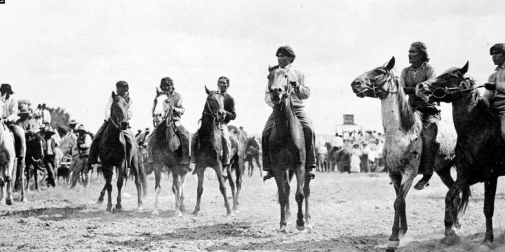
Horse & Foot races, Fun walk, Parade, traditional Navajo games and, entertainment for children, adults and senior.
Contact: Navajo Mountain Chapter (928) 672.2915 or 2916
7:00 am Fun Walk
9:00 am Horse Race
11:00 am Parade
1:00 pm Horse Race
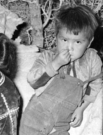
Title :Navajo Boy in Utah 1930s
Subject: Native Americans – Navajos
Photo courtesy of: Utah State Historical Society
Source donors: Utah Department of Publicity and Industrial Development
Photo Number: No. 22022
Navajo People Website Links:
Navajo Culture – Navajo History – Navajo Art – Navajo Clothing Navajo Pictures – Navajo Rugs – Navajo Language– Navajo Jewelry – Navajo Code Talker – Navajo Pottery – Navajo Legends – Hogan’s – Sand Painting – Navajo Food – Navajo News – Navajo Nation

Rainbow Bridge is the world’s largest known natural bridge.
From its base to the top of the arch, it is 290 feet-nearly the height of the Statue of Liberty-and spans 275 feet across the river. .The top is 42 feet (13 meters) thick and 33 feet (10 meters) wide.
The dark, vertical streaks onthe sandstone, called “desert varnish,” are composed of iron oxide or manganese. Many believe these particles leach from the rocks; others believe that minerals are blown as dust particles and settle on wetter areas of rock. Afternoon sunlight makes the colors especially brilliant.
The existence of this famed rock span was known to the Paiutes and Navajos long before its discovery by Anglo-Americans.
That discovery was shared by two veteran Southwestern scholars–Dr. Byron Cummings and William B. Douglass–who were united, albeit briefly, by John Wetherill, a famous Southwestern trader and explorer in his own right.
On August 11, 1909, the group began their trek to the bridge.
They were guided by Ute Mountain Ute Jim Mike, a member of the Douglass party who had supposedly heard about the bridge from the Navajos, and by John Wetherill, trader and self-taught archeologist.
Along the way they were to meet up with Paiute Nasja Begay, and Navajo Dogeye Begay.
Finally, late in the afternoon of August 14, the weary riders reached their goal.

William B. Douglas party, including Navajo Ute, and Paiute Indians, celebrate their discovery of Rainbow Bridge, Utah, as they eat watermelon in Paiute Canyon, 1909. – Photo by By N. Judd
To the Navajo people of the Southwest, Rainbow Bridge is not just a unique geological feature.
Navajo stories tell of a male and a female rainbow person coming together in perfect union, and being frozen in time.
This rock rainbow is particularly special because it is the only rainbow that can be viewed from both sides (Luckert 22-3). It is the site of ritual offerings, sacred ceremonies, and other religious practices.
Glen Canyon is home to several other sites of religious significance for the Navajo people, including a sacred spring, several rock beings, and the union of the feminine Colorado River and the masculine San Juan River.
However, these sites have all been covered by the waters of the manmade Lake Powell, disrupting Navajo spiritual practice (Luckert 24). One major concern of the Navajo is that the rock people are being drowned by Lake Powell.
Additionally, sacred offerings cannot be placed at the union of the Colorado and San Juan Rivers, as it is covered by water, which prevents the Navajo from properly conducting ceremonies that protect them from harsh weather and disease (Luckert 25).
Perhaps of more pressing concern than any of these other issues is the increasingly large presence of tourism in the Glen Canyon area. Because of the tourists, the Navajo people are not able to communicate with the spirits around Rainbow Bridge during the day, but the ceremonies cannot be conducted at night after the tourists have left because of the decrees of the spirits (Luckert 92-3).
Tourists are also often quite disrespectful of Navajo beliefs. Despite the posting of various signs asking them to avoid doing so, many tourists approach and walk under Rainbow Bridge, things that are expressly forbidden in the Navajo tradition.
One day the Twins were playing and they came to a canyon facing the north which is now Paiute Canyon. They could not get across when a worm came along and stretched his body across the canyon.
It was a shooting worm, wó nal?’ilí, and it later became Rainbow Bridge. According to this bridge, all bridges have been made in the same way. The worm did this himself for he had power.
After they were almost grown, both Twins lived at Navaho Mountain. They ran around Navaho Mountain four times from the east to the west and from the south to the north. When they had finished, they were full grown.
Works Cited:
Luckert, Karl W. Navajo Mountain and Rainbow Bridge Religion. Flagstaff: Museum of Northern Arizona
Navaho Legends by Matthews, Washington,- Navaho Legends.
Harrison Lapahie Jr. – lapahie.com
Sacred Land, Sacred View – Robert S. McPherson
Mount Blanca (Tsisnaasjini’ – Dawn or White Shell Mountain – East
Mount Taylor (Tsoodzil – Blue Bead or Turquoise Mountain) – South
San Francisco Peaks (Doko’oosliid – Abalone Shell Mountain) – West
Mount Hesperus Dibé Nitsaa (Big Mountain Sheep) – Obsidian Mountain – North
Navajo People Website Links:
Navajo Culture – Navajo History – Navajo Art – Navajo Clothing Navajo Pictures – Navajo Rugs – Navajo Language– Navajo Jewelry – Navajo Code Talker – Navajo Pottery – Navajo Legends – Hogan’s – Sand Painting – Navajo Food – Navajo News – Navajo Nation
by TheGuardian
“Monument Valley in Utah is one of the most iconic natural wonders of the world, its vast sandstone buttes familiar from countless Westerns, but few visitors explore its cultural life. Here Navajo guide Larry Holiday talks about life on the reservation and the challenges families face, as well as the beauty of the landscape”
The Four Corners Monument is the only place in the United States where four states (Arizona, Colorado, New Mexico, and Utah) come together at one place.
 Here you can stand in four states at the same time.
Photo by Harold Carey Jr.
The monument is maintained as a tourist attraction by the Navajo Nation Parks and Recreation Department.
The Four Corners region didn’t always have such a clear-cut divide. Part of Mexico until 1848, the area has since been home to countless squabbles over state lines.
The original marker erected in 1912 was a simple cement pad, but has since been redone in granite and brass. The Visitor Center is open year round, and features a Demonstration Center with Navajo artisans. Navajo vendors sell handmade jewelry, crafts and traditional Navajo foods nearby.
The monument was reconstruction in 2010. It consists of a granite disk embedded with a smaller bronze disk around the point, surrounded by smaller, appropriately located state seals and flags representing both the states and tribal nations of the area. Circling the point, with two words in each state, the disk reads, “Four states here meet in freedom under God.”

Picnic tables and self-contained restrooms are available. Services and accommodations are very limited to small cafes, grocery stores and self-service gasoline stations within a 30 mile radius.
We recommend that you have plenty of water, food, snacks, hand wipes and extra toiletries when visiting. The area is very remote, no running water, no electricity, no telephones.
Admission $3.00 (all ages)
Open 7 am – 8 pm (June – Sept)
Open 8 am – 5 pm (Oct – May)
Four Corners Park: 928-871-6647

There is a small visitor center, which is open year round. It features a Demonstration Center with Native American artisans. Vendors sell handmade jewelry, crafts and traditional foods nearby. Self-contained toilets are available.
Monument Valley (Navajo: Tsé Bii’ Ndzisgaii, meaning valley of the rocks) stretches across the state boundaries of northeast Arizona and southern Utah.
It is located on the border of southeastern Utah and northern Arizona, Monument Valley contains some of the most dramatic rock formations on the Colorado Plateau.

Hogans at Monument Valley Tribal Park
The valley’s earliest inhabitants include the Ice Age Paleo-Indian hunters (12,000-6,000 B.C.), Archaic hunter-gatherers (6,000 B.C.-A.D. 1), and Anasazi farmers (A.D. 1-1300).
In 1924 Harry Goulding established a post which is still in operation today, although under different management. During the 1950s Goulding encouraged the employment of Navajos in the uranium industry as well as in holding parts in the movie industry.

Monument Valley Tribal Park
Monument Valley became known throughout the world when it was featured in such western film classics as John Ford’s Stagecoach, She Wore a Yellow Ribbon, and Cheyenne Autumn.
The Navajo Nation just remodeled visitor center at one of the country’s most noted tribal parks.
Monument Valley Tribal Park, the destination of more than 250,000 visitors per year.
Monument Valley to hosts a balloon festival in February free and open to the public.
“All the staff at Monument Valley, they are all Navajo,” Hongeva said. “All the tour guides are Navajo and all the vendors who sell food or jewelry, they are Navajo, and they are all individuals who live there locally.”
Tour guides take visitors through the park’s 17 miles of scenic roads, past some of the most acclaimed formations of the American Southwest.
A $14 million lodging, called The View Hotel, was constructed on the nearly 30,000-acre park, where several Navajo families still maintain grazing rights.
Getting there:
From Flagstaff, head east on Highway 40 to Highway 89 (Page, Grand Canyon Exit). Travel north on Highway 89 to Highway 160. Travel east on Highway 160 to Highway 163 (Kayenta exit). Travel north into Utah to Goulding’s Lodge then take Indian Route 40 southeast to the entrance to Monument Valley. The closest airport is Farmington, New Mexico. It is about two and a half hours east of the park.
