“Anasazi Ruins” The Navajo Word of the Day (Video)

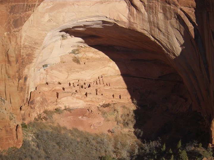
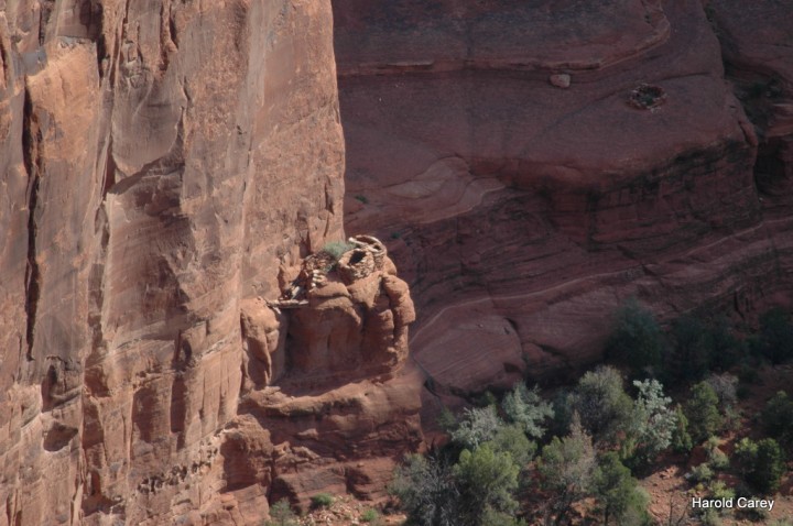
Today’s Navajo Word of the Day is the word for “Indian Ruins.” The word is, “Kits’iilí,” which literally means, “shattered homes.” This video was filmed at Mesa Verde National Park. The Navajo name for this area is called “Gad Deelzhah,” which means “Jagged Junipers.” Ruins such as these are typically called “kits’iilí.”

The ruins are made by the ancient peoples currently known as the Cliff Dwellers. They were formerly known as the Anasazi. Anasazi is a Navajo word, which means “Enemy’s Ancestor.” It comes from the words “anaa’í” for enemy and “bizází” for their ancestors. Since the Pueblo and Hopi tribes of today are considered to be the descendants of the Anasazi, they thought it was inappropriate for their ancestos to be named by Navajos so Cliff Dwellers is the current PC name.

I used this video to introduce other new terms as well, such as “haaz’éí” for ladder, “tsé daashjéé’ ” for corn-grinding stones or a metate, and “jeelid” for the sticky smoke soot that formed on the rock ceiling of the ruins from historic campfires.

I hope these terms help you if you decide to visit ancient ruins in the southwest such as these. Enjoy!

Source: Terry Teller (daybreakwarrior)
http://www.youtube.com/user/daybreakwarrior/featured


Inscription House Ruin Nitsie Canyon Arizona

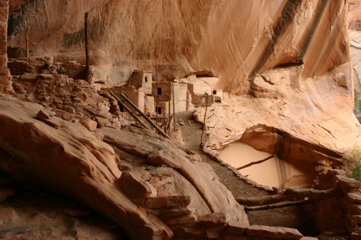
Located in the Navajo Reservation, the three sites—Betatakin (Navajo: “Ledge House”), Keet Seel (“Broken Pottery”; see photograph), and Inscription House—are among the best-preserved and most elaborate cliff dwellings known. The three sites, made a national monument in 1909.

Inscription House Ruin Navaho National Monument

Inscription House was partly built using a form of adobe brick. Unlike modern adobe bricks, these have ample amounts of grasses.

Inscription House. The latter ruin derives its name from an inscription scratched into the clay plaster of a wall. It reads, “Shapeiro Ano Dom 1661.” An intrepid early Spanish explorer or missionary, probably on his way to or from the Colorado River, must have entered the canyon in which this ruin is located and paused at the long-abandoned pueblo to scratch a record of his visit. So far as recorded it was not visited again until June, 1909.

Inscription House Ruin Navaho National Monument

Nitsie Canyon, in which Inscription House is located, is formed by a series of deep-cut canyons, whose courses zigzag in every direction like the tentacles of some huge devilfish, their rounded points and sides shimmering in the sunlight as though pulsating with life. At the rim one pauses in astonishment at this riot of color and form spread out below.

At Inscription House, the problems of Keet Seel were compounded by the nearby trading post and environmental problems. Since the 1930s, erosion had been visible in the wash below Inscription House. In the early 1940s, the wash eroded at the rate of about twenty feet per annum.

By 1944, it was “positively dangerous” to reach Inscription House.

In 1949, the ferocity of the flow of water caused a number of burials from the cave at Inscription House to wash out toward Lake Meade. Brewer found bones and high quality pottery in the wash after a heavy spring rain, prompting him to call for better protective measures against creeping erosion.

In addition, vandalism became more common at Inscription House in the early 1950s. Unauthorized visitors sometimes dug in the ruins. Local schoolchildren repeatedly scratched initials in the soft adobe walls. Clearly the Park Service had to take action.

But without an allocation of resources, any changes enacted remained largely cosmetic. Aubuchon optimistically concluded that the arduous trek to the outliers “precludes the person who has a mania for destruction,” but vandalism was an endemic problem.

The best mechanisms the regional office could offer were passive. Regional Director Tillotson advocated “a tightening of control over these isolated sections of the monument,” but no allocation to support those sentiments followed. Tillotson reiterated his longstanding opposition to directional signs for the trails to Keet Seel and Inscription House. He approved the idea that visitors should be required to register with the Park Service before they were allowed to proceed to either of the backcountry areas.
But
in the face of the declining condition of the two ruins, such remedies fell short of solving critical problems.

Inscription House, 36° 40′ 14″ north. 110° 51′ 32″ west.

Source: National Park Service

Betatakin Cliff Dwelling Ruins – AZ

Betatakin, part of Navajo National Monument, occupies a large cave in the north wall of an unnamed south fork of Laguna Canyon,1 which latter empties into Tyende Creek at Marsh Pass.

Betatakin Cliff Dwelling Ruins

Betatakin means “House Built on a Ledge” in Navajo.

About 15 miles northeast of the Pass is Kayenta, founded by Wetherill and Colville as a trading post late in 1909 and since grown into an oasis of peculiar charm—the home of several white families, chiefly associated with the local Navajo Indian hospital and its related activities.

It was inhabited by a semisedentary people. Following the so-called Basket Makers, first known agriculturists of the Southwest, came three other equally. distinct stages of tribal and material development to culminate in those great, communal towns of the Pueblo period—Betatakin, Keet Seel, and Inscription House.

It was first seen by whites on August 5, 1909, when a Utah University exploring party led by Prof. Byron Cummings and guided by John Wetherill was directed to it by a Navajo Indian, casually met in Segi Canyon.

This Indian pointed the way and then sat down beside the trail to await the party’s return. Through inherent fear of all things associated with the dead, he steadfastly refused to advance within sight of the ruin.

Betatakin Cliff Dwelling Ruins -2

Betatakin has about 120 rooms at the time of abandonment, but today only about 80 rooms remain.

Keet Seel (Kiet Siel “broken house” in Navajo)

Keet Seel (Kiet Siel “broken house” in Navajo)

Kiet Siel (Kits’iil, commonly spelled Keet Seel) which stands for “broken house” in Navajo, is a well preserved cliff dwelling of the ancient Anasazi people located in a branch of the Tsegi Canyon in the Kayenta region of Northeastern Arizona.

Keet Seel

The old Ancestral Puebloan ruins of Keet Seel were discovered by Richard Wetherill in early 1895 and made a national monument in 1909.

The site was first occupied at around AD 1250, during a time in which a large number of people were believed to be aggregating in sites such as this in this part of the American Southwest.

There was construction at Kiet Siel from AD 1272 to 1275, with construction halting completely at about AD 1286.

At its peak, its believed that up to 150 people inhabited the Kiet Siel this site at one time.

The Discovery of Keet Seel
Source: Fred M. Blackburn November 12, 2005

The Keet Seel cliff house had one room containing the valuables of several Navajo families. Visits there three different years found them there each time. One burial mound that was previously worked proved to be very rich in pottery and burials, more than 100 skeletons being removed and more than 400 pieces of pottery being saved and brought away entire.

The first work at Kiet Siel was done by a party led by Richard Wetherill, and financed by Theodore Bower [Bowles] in 1897. They left Mancos, Colorado, in October, 1896, and reached Kiet Siel in March 1897.

The notes, plans, photographs, and artifacts were turned over to the American Museum of Natural History, New York. W.B. Douglas surveyed and made a plan in August, 1909.

Dr. J. Walter Fewkes, of the Smithsonian Institution, visited the Kiet Siel ruins in September, 1909, and made out a report that came out later. There was a report of 1909 gotten out by Dean Cummings for the University of Utah.

In 1909 W.B. Douglas, of the Land Office in Washington, D.C., looked over the ruins and decided they should be made into a National Monument.

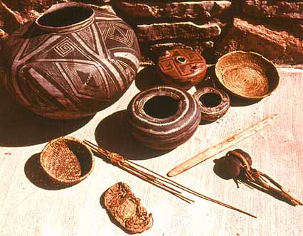
Most of the pottery is of the finest quality in designs of black and white which indicates a developed art in that direction that has not been rivaled. Some of the large ollas, particularly, measuring two feet across are perfect both in shape and design.

anasazi pottery

At the conclusion of the expedition Richard hoped to sell the collection, rumored at 2000 artifacts for $5500. He would split the collection proceeds with Whitmore and Bowles. Richard eventually settled for a sale to the Hyde brothers of $3000 in January of 1898.

STONE AXES
Several fine stone axes are lying about evidently discarded ones but of excellent workmanship and on examining the various timbers about the walls and roofs one can easily see that they were all cut with stone axes from the gnawed off appearance of the ends.

One huge timber lying directly across the front of the outer walls, possibly used at one time for a prop or support with a length of 40 feet and 14 inches in diameter, was cut and trimmed with stone axes which must have required considerable patience, skill, strength and time to cut, showing an admirable side of their character.

Antelope Canyon – Page Arizona

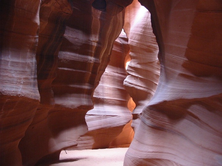
Antelope Canyon on the Navajo Nation near Page Arizona is the most-visited and most-photographed slot canyon in the American Southwest, mostly because it is easily accessible.

Antelope Canyon 1

It is located near Page on Navajo Nation land, just outside Glen Canyon National Recreation Area and close to AZ 98 a few miles east of town (at milepost 299).

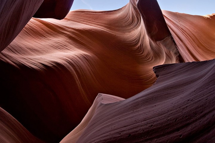
Antelope Canyon is a narrow, red-sandstone slot canyon with convoluted corkscrew formations, dramatically illuminated by light streaming down from above.

The best photos are taken at high noon, when light filters through the slot in the canyon surface.

Antelope Canyon 2


According to The Navajo Parks & Recreation:
The Navajo name for Upper Antelope Canyon is Tse’ bighanilini, which means “the place where water runs through rocks.”

A long time ago, herds of pronghorn antelope roamed freely in Antelope Canyon, which explains the canyon’s English name.

Upper Antelope is at about 4,000 feet elevation and the canyon walls rise 120 feet above the streambed.

Lower Antelope Canyon is Hasdestwazi, or “spiral rock arches.” Located within the LeChee Chapter of the Navajo Nation.

Antelope Canyon 3

Lake Powell Navajo Tribal Park Office
P.O. Box 4803
Page, AZ 86040
(928) 698-2808 voice (928) 698-2820 fax
email : ac@navajonationparks.org
http://navajonationparks.org/htm/antelopecanyonpark.htm

Entry Fees
General Admission (ages 8yrs & older) – $6.00
Ages 7 or younger – Free

Entrance Fee Station Hours (Mountain Standard Time year round)
Peak Season (late March – November 1) 8:00am – 5:00pm, 7 Days a week
Off Season (November 2 – early March) 9:00am – 3:00pm, 7 Days a week


Photo of Navajo Family in Corn Field

Navajo family in a corn field in northern New Mexico

Publisher: Center for Southwest Research, University Libraries, University of New Mexico
Date Original ca. 1920-1940


Canyon de Chelly – Chinle, AZ

Canyon de Chelly (pronounced “dee shay”) was authorized in 1931 by President Herbert Hoover as a National Monument in large measure to preserve the important archeological resources that span more than 4,000 years of human occupation.

Canyon de Chelly Spider Rock, home of Spider Woman - Photo by Harold Carey Jr.
Canyon de Chelly Spider Rock, home of Spider Woman – Photo by Harold Carey Jr.

The agreement left most of the landscape as the property of the Navajo Nation. About 40-50 Navajo families that own land on the canyon floor, continue to farm that land, raise livestock there in summer, and guide tours. They now grow Corn, squash, tomatoes, cherries, pears and apricots in the Valley. Cattle and horses roam some of the fields.

For nearly 5,000 years the main and side canyons of Canyon de Chelly have been occupied, the longest continuous stretch of habitation on the Colorado Plateau, according to the Park Service.

Canyon de Chelly White House Ruins - Photo by Harold Carey Jr.
Canyon de Chelly White House Ruins – Photo by Harold Carey Jr.

No Entrance Fee
There is no fee for park entrance; however, the park does appreciate donations. Donations can be dropped in the donation box inside the visitor center.

The Visitor Center is open daily all year from 8 a.m. to 5 p.m., except for Christmas Day.

Suggestions If You Just Have:
2 Hours – Visit all 7 overlooks on South Rim Drive OR visit all 3 overlooks on North Rim Drive.

1/2 Day – Visit all 10 overlooks on South and North Rim Drive OR Visit the South Rim Drive and hike the White House Trail OR join a half day guided tour.

1 Day – Visit all 10 overlooks on South and North Rim Drives plus hike the White House Trail OR visit all 10 overlooks plus join a half day guided tour OR join an all-day guided tour.

2 Days – Visit all 10 overlooks on the South and North Rim Drives, hike the White House Trail AND join an all-day guided tour.

Canyon de Chelly - Photo by Harold Carey Jr.
Canyon de Chelly – Photo by Harold Carey Jr.


Canyon de Chelly - Photo by Harold Carey Jr.
Canyon de Chelly – Photo by Harold Carey Jr.


Navajo Word of the Day: Fireworks (Video)


Since today is July the 4th, I figured a good word to use would be “fireworks.” To say fireworks in Navajo, you can say it one of two ways, “naaltsoos dildoní” or “naaltsoos dilchxoshí.” Naaltsoos means “paper” and dildoní means “the one that explodes.” In the same way, dilchxoshí means “the one that pops,” just like our past word of the day for popcorn, “naadáá’ dilchxoshí ,” for “corn that pops,” or “tó dilchxoshí” for soda pop (popping water).

To use it in a sentence, you can say “Ya’iishjáástsoh yizilígíí’ biyi’ díí’góó yoolkáálgóó naaltsoos dildoní da’dildon leh,” which means, “On the 4th of July, people usually pop fireworks.”

The breakdown:
Ya’iishjáástsoh: July
Yizilígíí’: that month
Biyi’: in it
Díí’góó: the 4th
Yoolkáálgóó: on that day
Naaltsoos dildoní: fireworks
Da’dildon: they pop/explode them
Leh: usually

Enjoy this word of the day & Happy 4th of July! 🙂

Four Corners Monument

The Four Corners Monument is the only place in the United States where four states (Arizona, Colorado, New Mexico, and Utah) come together at one place.

Four Corners Monument -2 Here you can stand in four states at the same time.
Photo by Harold Carey Jr.

The monument is maintained as a tourist attraction by the Navajo Nation Parks and Recreation Department.

The Four Corners region didn’t always have such a clear-cut divide. Part of Mexico until 1848, the area has since been home to countless squabbles over state lines.

The original marker erected in 1912 was a simple cement pad, but has since been redone in granite and brass. The Visitor Center is open year round, and features a Demonstration Center with Navajo artisans. Navajo vendors sell handmade jewelry, crafts and traditional Navajo foods nearby.

The monument was reconstruction in 2010. It consists of a granite disk embedded with a smaller bronze disk around the point, surrounded by smaller, appropriately located state seals and flags representing both the states and tribal nations of the area. Circling the point, with two words in each state, the disk reads, “Four states here meet in freedom under God.”

Four Corners Monument 3

Picnic tables and self-contained restrooms are available. Services and accommodations are very limited to small cafes, grocery stores and self-service gasoline stations within a 30 mile radius.

We recommend that you have plenty of water, food, snacks, hand wipes and extra toiletries when visiting. The area is very remote, no running water, no electricity, no telephones.

Admission $3.00 (all ages)
Open 7 am – 8 pm (June – Sept)
Open 8 am – 5 pm (Oct – May)
Four Corners Park: 928-871-6647

Four Corners Monument 1

There is a small visitor center, which is open year round. It features a Demonstration Center with Native American artisans. Vendors sell handmade jewelry, crafts and traditional foods nearby. Self-contained toilets are available.

Navajo Girl with Lamb in Monument Valley

Navajo Indians in Monument Valley. Monument Valley. North Window- tree on right.
By Joyce Betty.
Original format: Black and white polyester film negative
Original size: 4×5 inches
Date(s): 1950-1970